
What this drone GSD calculator does
Before a drone mapping flight you have to answer one question: how high should I fly? Fly too high and the map is not sharp enough to see what you need. Fly too low and the flight takes far longer, needs more batteries and creates thousands of extra photos to process. The number that links flight altitude to sharpness is the ground sample distance, and this ground sample distance calculator works it out for you.
Choose your drone from a list of common mapping drones and payloads: the DJI Mavic 3 Enterprise, Matrice 4E, Phantom 4 RTK, Zenmuse P1, Mini 4 Pro, Air 3, Autel EVO II Pro, Parrot ANAFI, WingtraOne, eBee X and more. The camera specs fill in by themselves. If your drone is not in the list, choose "Other drone" and type the sensor size, focal length and image size. If you only know the 35 mm equivalent focal length from a spec sheet, tick the box and the tool converts it to the real focal length.
The calculator works in both directions. In "GSD from altitude" mode you enter a flight altitude and get the GSD. In "Altitude from GSD" mode you enter the GSD your client asks for, for example 2 cm per pixel, and get the highest altitude that still delivers it. In both modes you also get the photo footprint, the distance between photos and flight lines for your overlap, and a rough photo count for a rectangular area. That makes it a quick drone mission planning tool: you know how many flight lines and photos a job needs before you open your flight planning app. Below the results the tool prints the full calculation with your own numbers, so you can check it or copy it into a flight plan report.
What is ground sample distance (GSD) in drone mapping?
Ground sample distance (also called ground sampling distance) is the distance between the centres of two neighbouring pixels, measured on the ground. Put simply: it is how big one pixel of your photo is in the real world. A GSD of 2 cm/px means each pixel covers a 2 × 2 cm square of ground. A smaller GSD means more detail. At 1 cm/px you can read the markings on a survey nail; at 5 cm/px you can see a car but not its number plate.
GSD decides more than how sharp the map looks. It also limits how accurate the map can be. Photogrammetry software such as Pix4D, Agisoft Metashape, DJI Terra and OpenDroneMap usually reaches a horizontal accuracy of 1 to 2 times the GSD and a vertical accuracy of 1 to 3 times the GSD, when you use good ground control points. So if a project needs 3 cm accuracy, a GSD of about 1.5 to 2 cm is the starting point.
Three things set the GSD: the flight altitude, the camera sensor and the lens. Fly twice as high and the GSD doubles. Use a camera with more pixels on the same sensor size, or a longer lens, and the GSD gets smaller. Things like overlap, speed and flight pattern do not change the GSD of a single photo, although the final orthomosaic is often exported at the GSD or slightly coarser.
The GSD formula and every other formula the tool uses
These are all the formulas behind the calculator. They are the standard formulas of aerial photogrammetry for a camera pointing straight down (nadir) over flat ground.
Symbols: H = flight height above ground (m), Sw and Sh = sensor width and height (mm), f = real focal length (mm), W and Hₚ = image width and height (px), f₃₅ = 35 mm equivalent focal length (mm).
Ground sample distance
GSD = (H × Sw) ÷ (f × W)
The main formula. Because Sw and f are both in millimetres, their units cancel, and the GSD comes out in the same unit as H. Multiply by 100 for cm/px. The tool also calculates the same thing with the sensor height and image height and reports the larger of the two values.
Flight altitude for a target GSD
H = GSD × min(f × W ÷ Sw, f × Hₚ ÷ Sh)
The GSD formula solved for H. Taking the smaller of the two terms makes sure that neither image axis is coarser than your target.
Photo footprint on the ground (image footprint)
Width = H × Sw ÷ f; Height = H × Sh ÷ f
The area one photo covers. It is the same as GSD × number of pixels on each side.
Field of view
FOV = 2 × atan(S ÷ (2 × f))
The angle the camera sees across the sensor width (horizontal FOV) or height (vertical FOV), in degrees.
Pixel size on the sensor (pixel pitch)
p = Sw ÷ W
The physical size of one pixel on the chip, shown in micrometres (µm). GSD is simply the pixel pitch scaled by H ÷ f.
Real focal length from the 35 mm equivalent
f = f₃₅ × √(Sw² + Sh²) ÷ 43.27
43.27 mm is the diagonal of a 36 × 24 mm full-frame sensor. Dividing it by your sensor diagonal gives the crop factor.
Distance between photos
B = footprint height × (1 − front overlap)
How far the drone flies between two shots on the same line. With 75% front overlap, it moves one quarter of the footprint.
Distance between flight lines
D = footprint width × (1 − side overlap)
How far apart the parallel lines of the flight pattern are.
Photos for a rectangular area
N = (⌈area width ÷ D⌉ + 1) × (⌈area length ÷ B⌉ + 1)
Lines across the area times photos on each line. The "+ 1" adds one line and one photo at the far edges so the borders are covered. Real flight apps add a buffer around the area, so treat this as a minimum.
Why the formula works: similar triangles
A camera is a pinhole with a lens. Light from the ground passes through the centre of the lens and falls on the sensor behind it. This gives two triangles that share the same angle at the lens: a small one between the lens and the sensor, and a large one between the lens and the ground.
Because the triangles have the same shape, their sides keep the same ratio: footprint width ÷ H = Sw ÷ f. So the footprint width is H × Sw ÷ f. That footprint is covered by W pixels, so one pixel covers (H × Sw ÷ f) ÷ W on the ground, which is exactly the GSD formula. The same logic in the other direction gives the footprint height from Sh.
Two details are easy to get wrong. First, f must be the real focal length of the lens, not the 35 mm equivalent printed on the box. Second, H is the height above the ground you are mapping, not above sea level and not always above the take-off point. If the site rises 30 m from where you launched, the GSD on the high part is smaller than the app shows.
Worked example: DJI Mavic 3 Enterprise at 80 m
Here is the full calculation for a DJI Mavic 3 Enterprise (M3E), one of the most popular mapping drones, flying at 80 m above flat ground with 75% front overlap and 70% side overlap over a 500 × 300 m site. These are also the default values of the tool, so you can follow along.
| Sensor width × height (Sw × Sh) | 17.3 × 13.0 mm (4/3″) |
| Real focal length (f) | 12.29 mm (24 mm equivalent) |
| Image size (W × Hₚ) | 5,280 × 3,956 px |
| Flight height (H) | 80 m |
- GSD across the width = (80 × 17.3) ÷ (12.29 × 5,280) = 1,384 ÷ 64,891 = 0.02133 m = 2.13 cm/px
- GSD across the height = (80 × 13.0) ÷ (12.29 × 3,956) = 1,040 ÷ 48,619 = 0.02139 m = 2.14 cm/px
- Footprint = 80 × 17.3 ÷ 12.29 = 112.6 m wide and 80 × 13.0 ÷ 12.29 = 84.6 m high, so about 9,529 m² (0.95 ha) per photo
- Field of view = 2 × atan(17.3 ÷ 24.58) = 70.3° horizontal and 2 × atan(13.0 ÷ 24.58) = 55.7° vertical
- Distance between photos = 84.6 × (1 − 0.75) = 21.2 m; distance between lines = 112.6 × (1 − 0.70) = 33.8 m
- Photos = (⌈300 ÷ 33.8⌉ + 1) × (⌈500 ÷ 21.2⌉ + 1) = 10 lines × 25 photos = 250 photos, on a flight path of about 5.3 km
Result: about 2.14 cm/px (0.84 in/px). That is sharp enough for construction progress maps and stockpile volumes, and with good ground control points it supports an accuracy of roughly 3 to 4 cm.
The other direction: what height gives 1 cm/px with a Zenmuse P1?
A survey client wants 1 cm/px. You fly a DJI Matrice 350 RTK with a Zenmuse P1 and its 35 mm lens (full frame 35.9 × 24 mm, 8,192 × 5,460 px).
- f × W ÷ Sw = 35 × 8,192 ÷ 35.9 = 7,987
- f × Hₚ ÷ Sh = 35 × 5,460 ÷ 24.0 = 7,963
- H = 0.01 m × min(7,987, 7,963) = 79.6 m
So you can fly at about 80 m and still get 1 cm/px. With the 24 mm lens you would have to drop to about 55 m for the same GSD, which means many more flight lines. This is why survey teams pick longer lenses for high-detail work.
GSD of popular drones at 100 m (328 ft)
This table uses the same drone database as the calculator. All values are for a flight height of 100 m above flat ground with the full-resolution photo mode. To get the GSD at another height, scale it: at 50 m the GSD is half, at 120 m it is 1.2 times the value below.
| Drone / camera | Sensor (mm) | Focal length | Image (px) | GSD at 100 m | Footprint at 100 m |
|---|---|---|---|---|---|
| DJI Mavic 3 Enterprise (M3E) | 4/3″ · 17.3 × 13.0 | 12.29 mm (24 mm) | 5,280 × 3,956 | 2.67 cm/px | 141 × 106 m |
| DJI Mavic 3 Multispectral (M3M) · RGB | 4/3″ · 17.3 × 13.0 | 12.29 mm (24 mm) | 5,280 × 3,956 | 2.67 cm/px | 141 × 106 m |
| DJI Mavic 3 Thermal (M3T) · 48 MP | 1/2″ · 6.4 × 4.8 | 4.44 mm (24 mm) | 8,000 × 6,000 | 1.80 cm/px | 144 × 108 m |
| DJI Matrice 4E · 20 MP | 4/3″ · 17.3 × 13.0 | 12.29 mm (24 mm) | 5,280 × 3,956 | 2.67 cm/px | 141 × 106 m |
| DJI Matrice 4T · 48 MP | 1/1.3″ · 9.6 × 7.2 | 6.7 mm (24 mm) | 8,064 × 6,048 | 1.78 cm/px | 143 × 107 m |
| DJI Matrice 3D (DJI Dock 2) | 4/3″ · 17.3 × 13.0 | 12.29 mm (24 mm) | 5,280 × 3,956 | 2.67 cm/px | 141 × 106 m |
| DJI Phantom 4 RTK | 1″ · 13.2 × 8.8 | 8.8 mm (24 mm) | 5,472 × 3,648 | 2.74 cm/px | 150 × 100 m |
| DJI Zenmuse P1 · 24 mm | Full frame · 35.9 × 24.0 | 24.0 mm (24 mm) | 8,192 × 5,460 | 1.83 cm/px | 150 × 100 m |
| DJI Zenmuse P1 · 35 mm | Full frame · 35.9 × 24.0 | 35.0 mm (35 mm) | 8,192 × 5,460 | 1.26 cm/px | 103 × 69 m |
| DJI Zenmuse P1 · 50 mm | Full frame · 35.9 × 24.0 | 50.0 mm (50 mm) | 8,192 × 5,460 | 0.88 cm/px | 72 × 48 m |
| DJI Zenmuse L2 · RGB 20 MP | 4/3″ · 17.3 × 13.0 | 12.29 mm (24 mm) | 5,280 × 3,956 | 2.67 cm/px | 141 × 106 m |
| DJI Zenmuse H20 / H20T · 12 MP | 1/2.3″ · 6.17 × 4.55 | 4.5 mm (24 mm) | 4,056 × 3,040 | 3.38 cm/px | 137 × 101 m |
| DJI Zenmuse X5S · 15 mm | 4/3″ · 17.3 × 13.0 | 15.0 mm (30 mm) | 5,280 × 3,956 | 2.19 cm/px | 115 × 87 m |
| DJI Zenmuse X4S | 1″ · 13.2 × 8.8 | 8.8 mm (24 mm) | 5,472 × 3,648 | 2.74 cm/px | 150 × 100 m |
| DJI Zenmuse X7 · DL 24 mm | Super 35 · 23.5 × 15.7 | 24.0 mm (36 mm) | 6,016 × 4,008 | 1.63 cm/px | 98 × 65 m |
| DJI Mavic 3 / 3 Classic / 3 Pro · Hasselblad | 4/3″ · 17.3 × 13.0 | 12.29 mm (24 mm) | 5,280 × 3,956 | 2.67 cm/px | 141 × 106 m |
| DJI Phantom 4 Pro / Pro V2.0 / Advanced | 1″ · 13.2 × 8.8 | 8.8 mm (24 mm) | 5,472 × 3,648 | 2.74 cm/px | 150 × 100 m |
| DJI Phantom 4 | 1/2.3″ · 6.17 × 4.55 | 3.61 mm (20 mm) | 4,000 × 3,000 | 4.27 cm/px | 171 × 126 m |
| DJI Phantom 3 Professional / Advanced | 1/2.3″ · 6.17 × 4.55 | 3.61 mm (20 mm) | 4,000 × 3,000 | 4.27 cm/px | 171 × 126 m |
| DJI Mavic 2 Pro | 1″ · 13.2 × 8.8 | 10.26 mm (28 mm) | 5,472 × 3,648 | 2.35 cm/px | 129 × 86 m |
| DJI Mavic 2 Zoom · 24 mm | 1/2.3″ · 6.17 × 4.55 | 4.386 mm (24 mm) | 4,000 × 3,000 | 3.52 cm/px | 141 × 104 m |
| DJI Mavic Pro / Pro Platinum | 1/2.3″ · 6.17 × 4.55 | 4.73 mm (26 mm) | 4,000 × 3,000 | 3.26 cm/px | 130 × 96 m |
| DJI Air 2S | 1″ · 13.2 × 8.8 | 8.38 mm (22 mm) | 5,472 × 3,648 | 2.88 cm/px | 158 × 105 m |
| DJI Mavic Air 2 · 48 MP | 1/2″ · 6.4 × 4.8 | 4.5 mm (24 mm) | 8,000 × 6,000 | 1.78 cm/px | 142 × 107 m |
| DJI Air 3 · 24 mm 48 MP | 1/1.3″ · 9.6 × 7.2 | 6.7 mm (24 mm) | 8,064 × 6,048 | 1.78 cm/px | 143 × 107 m |
| DJI Mini 4 Pro · 48 MP | 1/1.3″ · 9.6 × 7.2 | 6.7 mm (24 mm) | 8,064 × 6,048 | 1.78 cm/px | 143 × 107 m |
| DJI Mini 3 / Mini 3 Pro · 48 MP | 1/1.3″ · 9.6 × 7.2 | 6.7 mm (24 mm) | 8,064 × 6,048 | 1.78 cm/px | 143 × 107 m |
| DJI Mini 2 / Mini SE / Mavic Mini | 1/2.3″ · 6.17 × 4.55 | 4.49 mm (24 mm) | 4,000 × 3,000 | 3.44 cm/px | 137 × 101 m |
| Autel Robotics EVO II Pro / Pro RTK (6K) | 1″ · 13.2 × 8.8 | 10.6 mm (29 mm) | 5,472 × 3,648 | 2.28 cm/px | 125 × 83 m |
| Autel Robotics EVO II (8K) · 48 MP | 1/2″ · 6.4 × 4.8 | 4.81 mm (26 mm) | 8,000 × 6,000 | 1.66 cm/px | 133 × 100 m |
| Parrot ANAFI · 21 MP | 1/2.4″ · 5.92 × 4.44 | 3.93 mm (23 mm) | 5,344 × 4,016 | 2.82 cm/px | 151 × 113 m |
| senseFly (AgEagle) eBee X · S.O.D.A. 3D | 1″ · 13.2 × 8.8 | 10.6 mm (29 mm) | 5,472 × 3,648 | 2.28 cm/px | 125 × 83 m |
| Wingtra WingtraOne Gen II · Sony RX1R II | Full frame · 35.9 × 24.0 | 35.0 mm (35 mm) | 7,952 × 5,304 | 1.29 cm/px | 103 × 69 m |
| Sony Airpeak S1 · α7R IV + 24 mm | Full frame · 35.7 × 23.8 | 24.0 mm (24 mm) | 9,504 × 6,336 | 1.57 cm/px | 149 × 99 m |
Specs come from the makers' published data. Where only the 35 mm equivalent was published, the real focal length was calculated from it. Your own camera may differ slightly, for example in a 16:9 photo mode, so check the EXIF of one of your photos when precision matters.
How the calculator handles the tricky parts
Most GSD calculators only show the main formula. Real cameras and real flights have a few details that change the answer, and this is how the tool deals with them.
- It reports the worse of two axes. A sensor's pixels are not always exactly square once you use the published sensor size and image size, so the GSD across the width and across the height can differ slightly. The tool shows both and uses the larger (coarser) one as the headline value, the same choice Pix4D makes. This way you never promise a client more detail than you can deliver.
- It wants the real focal length. Spec sheets love the 35 mm equivalent focal length ("24 mm"), but the formula needs the physical focal length of the lens, which is usually much shorter (12.29 mm on the Mavic 3 Enterprise). Using the equivalent number by mistake makes the GSD look two to five times smaller than it really is. If you only have the equivalent, tick the checkbox and the tool converts it with the sensor diagonal.
- It assumes the standard photo orientation. Mapping apps such as DJI Pilot 2, DJI GS Pro, Pix4Dcapture and DroneDeploy usually turn the camera so the long side of the photo lies across the flight line. That is why front overlap uses the short side of the footprint and side overlap the long side. If your app does it the other way round, swap the two overlap values.
- Height means height above the ground. The tool cannot know your terrain. If the ground rises or falls across the site, enter the height above the lowest part for a worst-case GSD, or use terrain follow in your flight app. On a site with a 30 m hill flown at 100 m above take-off, the GSD on the hilltop is 30% smaller than at the base.
- 48 MP sensors are counted at full size. Drones such as the Mini 4 Pro, Air 3 and Mavic 3 Thermal use a Quad Bayer sensor. In 48 MP mode the GSD is calculated from 8,064 or 8,000 pixels across, but the real detail is closer to a 12 MP photo, because four pixels share one color filter. If you shoot 12 MP mode, type the smaller image size (for example 4,032 × 3,024) and the GSD doubles.
- It shows you the math. Every number in the results comes with its formula and your own values in the box below. You can check the logic, catch a typing mistake in the specs, or paste the calculation into a flight plan or a client report.
Which GSD do you need? Recommended values by project
There is no single "right" GSD. It depends on what you need to see or measure. These are the ranges I would start from. The last column shows the drone mapping altitude for a DJI Mavic 3 Enterprise, so you get a feel for the numbers.
| Project | Typical GSD | Altitude with Mavic 3 Enterprise |
|---|---|---|
| Close inspection (cracks, bolts, roof damage) | 0.3 to 0.5 cm/px | 11 to 19 m |
| Survey-grade topographic mapping with GCPs | 1 to 2 cm/px | 37 to 75 m |
| Construction progress and stockpile volumes | 2 to 3 cm/px | 75 to 112 m |
| Agriculture and crop health checks | 3 to 5 cm/px | 112 m, then limited by the 120 m rule |
| Large area overview, forestry, flood mapping | 5 to 10 cm/px | Above 120 m: use a fixed-wing drone, a wider sensor or a permit |
My take: pick the largest GSD that still shows what you need. Halving the GSD means flying at half the height, which needs about four times as many photos and four times the processing time for the same area.
How to calculate GSD for your drone, step by step
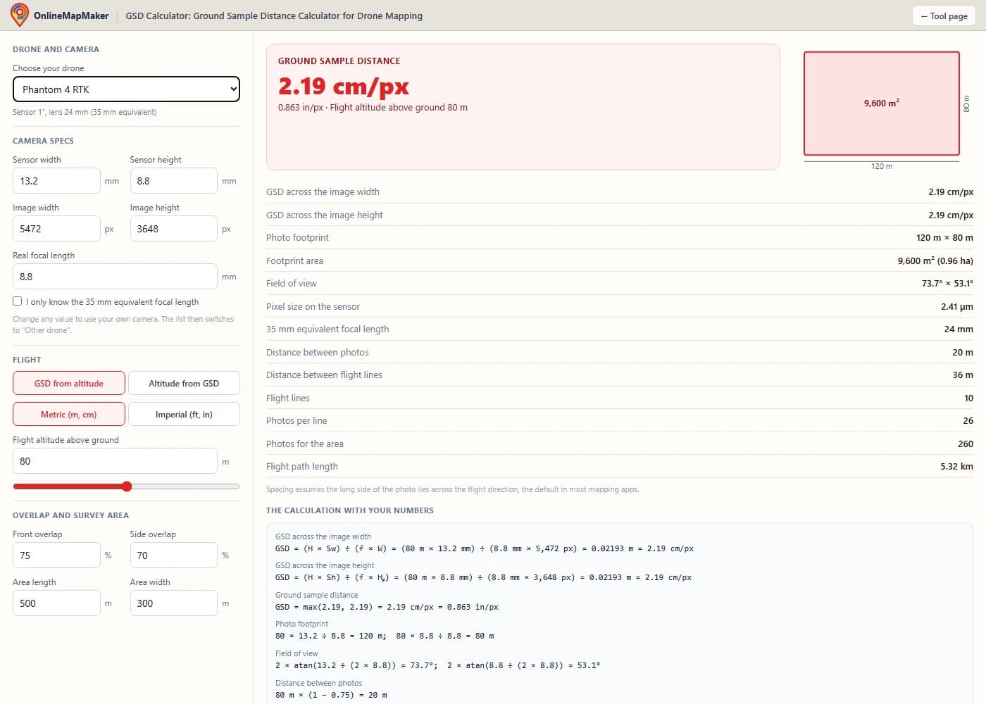
Choose your drone or camera from the list. The sensor size, real focal length and image size fill in automatically, and the line under the list shows the sensor type and the 35 mm equivalent lens.
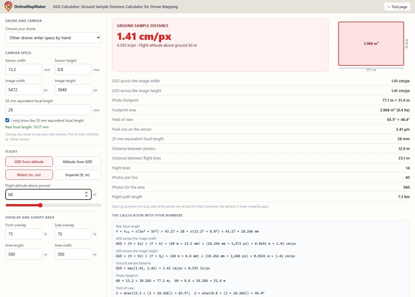
If your drone is not in the list, choose "Other drone: enter specs by hand" and type the five values from the spec sheet or from a photo's EXIF. Tick the checkbox if you only know the 35 mm equivalent focal length.
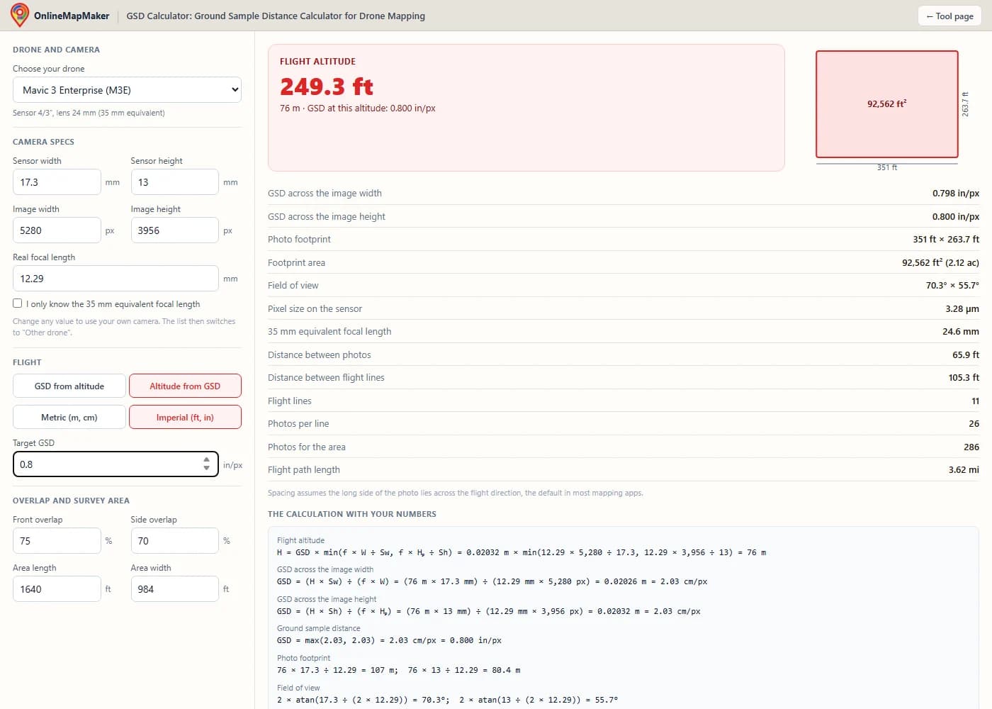
Pick the mode and units. "GSD from altitude" needs a flight altitude; "Altitude from GSD" needs your target GSD. Switch between metric and imperial at any time and the values convert.
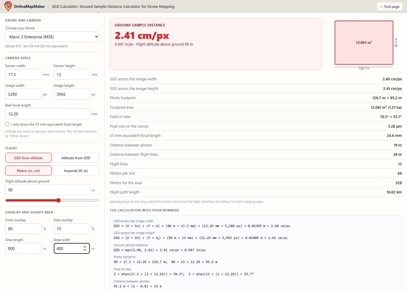
Enter the front and side overlap of your mission and the length and width of the area. The tool gives the distance between photos and lines, the number of flight lines and a photo count.
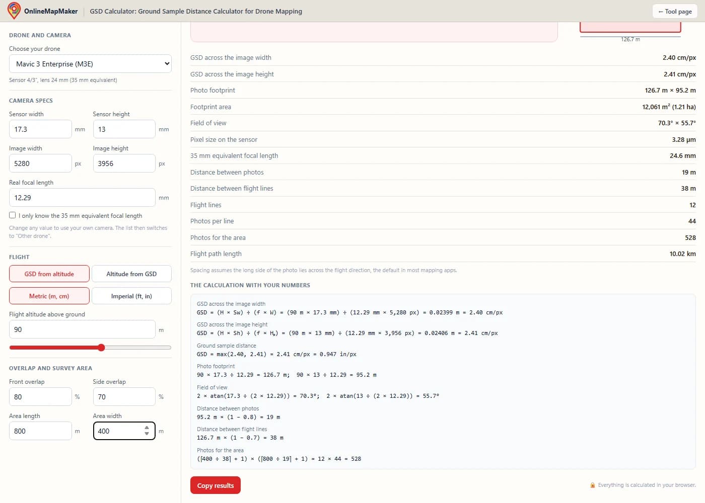
Read the results and the step-by-step calculation. Click "Copy results" to paste everything into a flight plan, an email or a project report.
Who uses a GSD calculator
Anyone who plans a drone mapping flight or has to promise a level of detail before flying.
- Land surveyors. Check that a flight height meets the GSD and accuracy written in a tender, and document the calculation in the survey report.
- Construction and mining teams. Choose one height for weekly progress flights, so every orthomosaic and stockpile volume has the same resolution and can be compared.
- Farmers and agronomists. Balance detail against battery time when mapping large fields for crop health, and estimate how many photos a field will need.
- Roof and solar inspectors. Find the height at which cracks, hail damage or panel defects become visible in the photos, before climbing onto anything.
- Drone pilots buying a new drone. Compare the GSD and footprint of a Mini 4 Pro, Mavic 3 Enterprise and Zenmuse P1 at the same height to see which camera fits the work.
- Students and teachers. Learn how sensor size, focal length and height work together, with every formula written out next to the result.
Flown your mission? Turn the photos into one georeferenced map with our Drone Image Stitcher & Orthomosaic Maker, which also uses the GSD to set the pixel size of the GeoTIFF.
Frequently asked questions
How do I calculate GSD for my drone?
Multiply the flight height by the sensor width, then divide by the focal length times the image width in pixels: GSD = (H × Sw) ÷ (f × W). Use metres for H and millimetres for Sw and f, and you get metres per pixel; multiply by 100 for cm/px. For example, a Phantom 4 RTK at 100 m: (100 × 13.2) ÷ (8.8 × 5,472) = 0.0274 m, or 2.74 cm/px.
What is a good GSD for drone mapping?
For most mapping jobs, 1 to 3 cm/px is a good range. Use 1 to 2 cm/px for survey-grade work with ground control points, 2 to 3 cm/px for construction progress and volumes, and 3 to 5 cm/px for agriculture or large-area overviews. Inspections of small details need 0.5 cm/px or less.
What altitude do I need for a 1 cm GSD?
It depends on the camera. A DJI Mavic 3 Enterprise needs about 37 m, a Phantom 4 RTK about 36 m, a Mini 4 Pro about 56 m in 48 MP mode, and a Zenmuse P1 with the 35 mm lens about 80 m. Choose "Altitude from GSD" in the tool and enter 1 cm/px to get the exact value for your drone.
What is the DJI Mavic 3 Enterprise GSD at 80, 100 and 120 m?
About 2.67 cm/px at 100 m, 2.14 cm/px at 80 m and 3.2 cm/px at 120 m. DJI writes it as H ÷ 36.5 in cm per pixel, which gives 2.74 cm/px at 100 m. The small difference comes from the exact sensor width DJI uses, and both values are fine for planning.
What is the Phantom 4 RTK GSD at 100 m?
About 2.74 cm/px. The Phantom 4 RTK has a 1-inch sensor (13.2 × 8.8 mm), an 8.8 mm lens and 5,472 × 3,648 pixel photos. DJI quotes H ÷ 36.5 cm per pixel, which is the same 2.74 cm/px at 100 m.
Is a lower GSD better?
A lower GSD shows more detail and allows better accuracy, but it is not always better for the project. To halve the GSD you fly at half the height, which needs about four times as many photos, more batteries and more processing time. Pick the largest GSD that still shows what you need.
Does terrain change the GSD?
Yes. The GSD depends on the height above the ground in each photo, not above the take-off point. When the ground rises toward the drone, the GSD gets smaller; when it falls away, the GSD gets larger. On hilly sites, use terrain follow in your flight app or calculate with the height above the lowest point.
GSD vs accuracy: what is the difference?
GSD is the size of one pixel on the ground. Accuracy is how close a measured point is to its true position. Good photogrammetry with ground control points usually reaches 1 to 2 × GSD horizontally and 1 to 3 × GSD vertically. Without ground control points or RTK, the map can be very sharp but still shifted by a metre or more.
Why does my flight app show a slightly different GSD?
Apps use slightly different sensor sizes, some round the value, and some use the image width only while this tool reports the coarser of width and height. Differences of 2 to 5% are normal. A larger difference usually means the 35 mm equivalent focal length was used instead of the real one, or a different photo mode is set.
Where do I find the real focal length and sensor size of my camera?
Open one of your drone photos in a metadata viewer and look for the FocalLength tag (the real focal length) and the image width and height. The sensor size is in the maker's spec sheet, usually as a type like 1″ or 4/3″. Common sizes are 13.2 × 8.8 mm for 1-inch, 17.3 × 13.0 mm for 4/3 and 6.17 × 4.55 mm for 1/2.3-inch sensors.
Do 48 MP drones really halve the GSD of 12 MP drones?
On paper, yes: twice the pixels across the same sensor halves the GSD. In practice, Quad Bayer 48 MP sensors in drones like the Mini 4 Pro and Air 3 resolve less detail than the pixel count suggests. Many mappers use their 12 MP mode for mapping, which gives fewer, cleaner photos with twice the GSD.
How do I convert GSD from cm per pixel to inches per pixel?
Divide by 2.54. So 2.54 cm/px is 1 in/px, and 2 cm/px is about 0.79 in/px. Switch the tool to imperial units and it shows inches per pixel first, with cm/px next to it.
Does overlap change the GSD?
No. The GSD of each photo depends only on height, sensor and lens. Overlap changes how many photos you take and how well the software can match them. More overlap gives a more reliable 3D model, especially over trees and crops, but the same GSD.
How many photos will my survey need?
Enter the area length and width in the tool. It divides the area by the distance between flight lines and between photos for your overlap. For example, a Mavic 3 Enterprise at 80 m with 75/70% overlap needs about 250 photos for a 500 × 300 m site. Flight apps add a buffer around the area, so expect a little more.
The calculator assumes a camera pointing straight down over flat ground and uses published camera specs, which can differ slightly from your unit. Values are for planning. Check local flight height rules before you fly. All calculations run in your browser, and nothing you enter is stored on a server.