

What this deed plotter does
Most property in the eastern US, Texas and a lot of other places is described by metes and bounds: a walk around the boundary, one call at a time. "Thence N 45°30' E 120.50 feet to an iron pin; thence S 44°30' E 85 feet..." Reading that paragraph tells you almost nothing about the shape of the land. Plotting it does. This free deed plotter turns the calls into a scaled drawing in a second, so you can see the shape, check the acreage, and spot a bad call before it costs you money.
You can paste the whole legal description straight from the deed, title commitment or survey, with all the "beginning at", "thence" and "to an iron rod found" wording in it. The tool finds each bearing and distance by itself, skips the monument descriptions, and tells you about any call it could not read. If you would rather type, put one call per line, like N 45°30'15" E 120.50, or use the small "Add a call" form. Curves, tie lines from a point of commencement, and "passing at ... in all" distances are all handled.
Next to the drawing you get the numbers a surveyor would check first: area in acres and square feet, perimeter, the error of closure and its precision ratio, and the closing call that would take you back to the point of beginning. The table lists the latitude and departure of every course and the coordinates of every corner. When the plot looks right, put it on the map at its real starting corner and download KML, GeoJSON, DXF, a PNEZD point file or a PNG image. Nothing is uploaded. Your deed stays in your browser.
Metes and bounds, PLSS, and lot and block: the three ways US land is described
Every legal description in the US uses one of three systems, and often two of them together. The deed plotter is built for the first one.
- Metes and bounds. "Metes" are the measurements (bearings and distances) and "bounds" are the boundaries and monuments (a creek, a stone, an iron pin, the land of a neighbor). The system came over from England and is the only system in the 13 original colonies, plus Maine, Vermont, West Virginia, Kentucky, Tennessee, Texas and Hawaii. Ohio's Virginia Military District uses it too. Even in states that use the PLSS, odd-shaped parcels, road right-of-way takings and splits are usually written in metes and bounds.
- Public Land Survey System (PLSS). Set up by the Land Ordinance of 1785 and used in 30 states, from Ohio west. Land is split into townships of 6 by 6 miles, each made of 36 sections of 1 square mile (640 acres). A description looks like "the NE 1/4 of the SW 1/4 of Section 12, Township 3 North, Range 5 West". That is an aliquot description, not a set of bearings, so the deed plotter cannot draw it by itself.
- Lot and block (recorded plat). In a subdivision the developer records a plat at the county, and a deed just says "Lot 14, Block C, Oak Hollow Subdivision, Plat Book 22, Page 41". The plat itself carries the bearings, distances and curve data. Type those from the plat into the plotter and you get the same lot drawing with an area check.
A tip from experience: if a metes and bounds deed starts with "commencing at the northeast corner of Section 12", it mixes two systems. The tie runs from a PLSS corner to the point of beginning, and the tract itself is metes and bounds. The deed plotter draws the tie as a dashed line and leaves it out of the area.
How to read a bearing in a legal description
A bearing tells you the direction of a property line. US deeds almost always write it as a quadrant bearing: start at north or south, turn a number of degrees toward east or west.
- Quadrant bearing: N 45°30'15" E. Face north, turn 45 degrees, 30 minutes and 15 seconds toward the east, and walk. One degree has 60 minutes, and one minute has 60 seconds. S 12°10' W means face south and turn 12°10' toward the west.
- Azimuth: 225°30'. A direction from 0° to 360°, measured clockwise from north. Engineers and GIS use it more than deeds do. Type AZ in front of it, like AZ 225°30' 100. S 45°30' W and an azimuth of 225°30' are the same line.
- Due north, east, south or west. A line straight along a cardinal direction is often written "North 120 feet" or "due East". You can type N 120 or E 85 and the plotter reads it.
- The basis of bearings. Every bearing is measured from some reference. Old deeds used the compass needle, so their bearings are magnetic, and magnetic north moves a little every year. Modern surveys state a basis of bearings, for example grid north of a State Plane zone or the bearing of a known road centerline. Two deeds for neighboring lands can disagree by a degree or two only because they use a different basis. The "Rotate all bearings" option turns the whole plot to fix that.
Reverse a bearing by swapping both letters: the line N 45°30' E walked the other way is S 45°30' W. Mixing up one letter (N for S, or E for W) is the most common typo in a typed deed, and it shows up right away as a large misclosure.
Ways to type deed calls
The plotter accepts the formats you find in real deeds, plats and survey notes. You can mix them in one description. Here is what it understands:
| You type | The deed plotter reads it as |
|---|---|
| N 45°30'15" E 120.50 | Quadrant bearing in degrees, minutes and seconds; the distance is in the default unit you pick |
| N45-30-15E 120.5 | The short form many surveyors type, with dashes in place of the symbols |
| N 45 30 15 E 120.5 ft | Spaces only, with the unit written after the distance |
| North 45 degrees 30 minutes 15 seconds East 120.50 feet | The spelled-out form of older deeds |
| S 52½ W 64 poles | Fractions of a degree and old units (½, ¼, ¾ and "52 1/2" all work) |
| AZ 225°30' 100 m | An azimuth from north, 0° to 360° |
| E 6 chains 25 links | Due east; chains and links are added together (6.25 chains = 412.5 feet) |
| S 45 E passing a rebar at 50.00 feet, in all 120.00 feet | The total distance after "in all", not the passing distance |
| TIE S 00°12'30" W 35.00 | A tie line from the point of commencement to the POB: drawn dashed, not part of the area |
| C R=300 L=150 CB=N30E RIGHT | A curve with its radius, arc length, chord bearing and direction |
| CURVE LEFT R 100 DELTA 45°00' CB S 22°30' W CD 76.54 | A curve with its central angle (delta) and chord distance |
When you paste a full legal description with the word "thence" in it, the plotter switches to deed-text mode. It splits the text at every "thence", skips the "Beginning at..." or "Commencing at..." part, and takes everything up to the first mention of the "point of beginning" as the tie. Line breaks from a scanned PDF do not matter in this mode. If a call has no bearing at all, like "thence along the meanders of Mill Creek", the plotter lists it as skipped, and you will see the gap as misclosure.
Feet, chains, rods, poles, perches and varas: old deed units converted
Pick the unit for distances that have no unit written after them. Distances with a unit (feet, ft, ', chains, links, rods, poles, perches, varas, yards, meters) are read in that unit, so one deed can mix them.
| Unit | Feet | Meters | Where you will see it |
|---|---|---|---|
| Foot | 1 | 0.3048 | Almost every deed and plat written since the early 1900s |
| US survey foot | 1.000002 | 0.3048006 | State Plane coordinates and surveys before 2023; officially retired at the end of 2022 |
| Gunter's chain | 66 | 20.1168 | Original government (PLSS) surveys and 18th and 19th century deeds; 80 chains make a mile |
| Link | 0.66 (7.92 in) | 0.201168 | Same surveys as the chain; 100 links make a chain |
| Rod, pole or perch | 16.5 | 5.0292 | Colonial deeds in Virginia, Pennsylvania, Maryland, the Carolinas and Kentucky; all three names are the same length |
| Vara (Texas) | 2.7778 (33⅓ in) | 0.8467 | Texas land grants and many Texas surveys to this day |
| Yard | 3 | 0.9144 | Rare in deeds |
| Meter | 3.2808 | 1 | Rare in US deeds, common in GIS and engineering plans |
For area: one acre is 43,560 square feet, which is also 10 square chains or 160 square rods. In Texas, a labor is 1,000,000 square varas (about 177.1 acres) and a league is 25,000,000 square varas (about 4,428 acres). Results show in feet and acres or in meters and hectares, your choice.
Curves in a legal description
Subdivision lots, road frontage and cul-de-sacs almost always have curved lines. A deed describes a curve by its curve data, usually written like this: "thence along a curve to the right having a radius of 25.00 feet, an arc length of 39.27 feet, a chord bearing of N 45°12'30" E and a chord distance of 35.36 feet". The deed plotter reads that sentence as it is. In line mode, write it short: C R=25 L=39.27 CB=N45-12-30E CD=35.36 RIGHT.
- Direction (right or left). Which way the line bends as you walk it. A curve to the right has its center on your right.
- Radius (R). The radius of the circle the arc is part of. It is the one value every curve needs.
- Arc length (L), central angle (Δ or delta) or chord distance (CD). Any one of these, with the radius, fixes the size of the curve. If the deed gives more than one, the plotter uses the delta first, then the arc length, then the chord.
- Chord bearing (CB). The bearing of the straight line from the start of the curve (PC, point of curvature) to its end (PT, point of tangency). If a deed leaves it out and says the curve is tangent, the plotter takes the previous course as the tangent direction and works the chord bearing out from it.
The curve formulas the plotter uses, with Δ in radians for the arc and the segment:
L = R × Δ
Chord = 2 × R × sin(Δ ÷ 2)
T = R × tan(Δ ÷ 2)
Segment = R² ÷ 2 × (Δ − sin Δ)
The area of a curved lot is the straight-line polygon through the corners plus or minus the circular segment between each chord and its arc. That segment can be large: for a 25-foot radius corner with a 90° delta it is 178 square feet, and it matters on small city lots.
Error of closure: does your deed close?
A boundary has to end where it started. When you plot the calls one after another, the end of the last call should land right on the point of beginning. It almost never lands there exactly. The gap is the error of closure (also called the misclosure or linear error), and the deed plotter shows it in feet together with the closing call, the bearing and distance from the last corner back to the POB.
The size of the gap on its own does not say much: 0.5 feet is poor on a city lot and excellent on a 500-acre ranch. So surveyors divide the perimeter by the error and write the result as a ratio, the precision. A perimeter of 2,000 feet with a 0.2-foot error closes at 1:10,000. A rough guide to what the number means:
| Precision | What it usually means |
|---|---|
| 1:20,000 or better | Modern survey grade, or a computed description from a recent plat |
| 1:10,000 to 1:20,000 | A good modern boundary survey |
| 1:5,000 to 1:10,000 | Normal for rural surveys of the late 20th century |
| 1:1,000 to 1:5,000 | Older transit-and-tape work; fine to see the shape |
| Worse than 1:1,000 | Normal for compass-and-chain deeds before about 1900; in a modern deed, look for a typo or a missing call |
Tick "Balance the misclosure with the compass rule" to spread the error over all the courses in proportion to their length. This is the Bowditch method, the standard way to adjust a traverse by hand. It moves each corner a little, closes the figure, and gives a slightly different area. It does not make a bad deed right: if one call has a typo, the compass rule smears that one mistake over every corner.
Modern ALTA/NSPS land title surveys no longer use a ratio. They use relative positional precision: 0.07 feet (2 cm) plus 50 parts per million between any two corners. Many states also have their own minimum standards. A deed plot is not a survey, but if a recent deed closes worse than about 1:5,000, ask the surveyor or the title company about it before you close.
The math behind a deed plot
Plotting a deed is a traverse calculation, the same one surveyors did with a book of trig tables and a pencil. These are all the formulas the plotter uses. D is the distance of a course, Az its azimuth, θ the angle in a quadrant bearing, and P the perimeter.
Quadrant bearing to azimuth
NE: Az = θ SE: Az = 180° − θ SW: Az = 180° + θ NW: Az = 360° − θ
Every bearing is first turned into an azimuth so all courses use one rule. Your rotation, if you set one, is added here.
Latitude (change in northing)
Lat = D × cos(Az)
How far a course moves north (plus) or south (minus).
Departure (change in easting)
Dep = D × sin(Az)
How far a course moves east (plus) or west (minus).
Corner coordinates
N₂ = N₁ + Lat E₂ = E₁ + Dep
Starting from the northing and easting you pick for the first point (5000 / 5000 by default, a common assumed value).
Error of closure
e = √( (ΣLat)² + (ΣDep)² )
On a perfect traverse the latitudes and the departures each add up to zero. What is left over is the error.
Precision
Precision = 1 : (P ÷ e)
Perimeter divided by the error, shown as a ratio. Arc lengths count in the perimeter.
Area by coordinates (shoelace formula)
A = ½ × | Σ (Eᵢ × Nᵢ₊₁ − Eᵢ₊₁ × Nᵢ) |
The area of the polygon through all corners. Before computers, surveyors got the same number with the double meridian distance (DMD) method. Curve segments are then added or taken away.
Compass rule (Bowditch) correction
cLat = −ΣLat × (D ÷ P) cDep = −ΣDep × (D ÷ P)
Each course gets a share of the error in proportion to its length. Used only when you tick the option.
Worked example: a four-sided residential lot
Here is the "Residential lot" sample from the tool, worked by hand. The calls are N 12°15'00" E 125.00 ft, S 79°30'20" E 210.45 ft, S 08°02'10" W 141.07 ft and N 75°21'05" W 220.88 ft, starting from assumed coordinates of 5000.000 N and 5000.000 E.
| # | Course | Latitude | Departure | Northing | Easting |
|---|---|---|---|---|---|
| POB | 5,000.000 | 5,000.000 | |||
| 1 | N 12°15'00" E 125.00 | +122.154 | +26.522 | 5,122.154 | 5,026.522 |
| 2 | S 79°30'20" E 210.45 | −38.331 | +206.930 | 5,083.822 | 5,233.452 |
| 3 | S 08°02'10" W 141.07 | −139.685 | −19.721 | 4,944.138 | 5,213.731 |
| 4 | N 75°21'05" W 220.88 | +55.858 | −213.700 | 4,999.996 | 5,000.030 |
- Course 1: Az = 12.25°. Lat = 125.00 × cos 12.25° = +122.154. Dep = 125.00 × sin 12.25° = +26.522.
- Course 2: Az = 180° − 79.5056° = 100.4944°. Lat = 210.45 × cos 100.4944° = −38.331. Dep = +206.930.
- Course 3: Az = 180° + 8.0361° = 188.0361°. Lat = −139.685. Dep = −19.721.
- Course 4: Az = 360° − 75.3514° = 284.6486°. Lat = +55.858. Dep = −213.700.
- Sum of latitudes = −0.004 ft. Sum of departures = +0.030 ft. Error of closure = √(0.004² + 0.030²) = 0.031 ft.
- Perimeter = 125.00 + 210.45 + 141.07 + 220.88 = 697.40 ft. Precision = 697.40 ÷ 0.031 = 1:22,700.
- Area by coordinates = 28,625 sq ft. Divide by 43,560 to get 0.657 acres.
Result: the lot closes at about 1:22,700, which is survey grade, and holds about 0.657 acres. The closing call from the last corner back to the POB is N 82°50'53" W 0.03 ft, so small that it is only rounding in the deed.
Point of beginning, point of commencement and tie lines
Every metes and bounds description starts at the point of beginning, the POB. It is usually a monument you can find on the ground: "an iron rod found at the southwest corner of the Harper tract", "a stone in the north line of State Route 9". The description walks the boundary from there, call by call, and the last call ends "to the point of beginning".
Sometimes the POB is not at a known monument. Then the deed starts at a better-known point, the point of commencement (POC), and runs one or more tie calls to reach the POB: "Commencing at the northeast corner of Lot 14; thence S 00°12'30" W 35.00 feet to the POINT OF BEGINNING". The ties locate the tract but are not part of it. The deed plotter draws them dashed and gray, labels the start POC, and leaves them out of the area and the closure. Some deeds write "true point of beginning" for the same idea.
In deed-text mode the plotter finds the ties by itself: if the text starts with "commencing", every call up to the first "point of beginning" (or "place of beginning", common in Texas, or "P.O.B.") is a tie. In line mode, start the tie lines with the word TIE.
When the plot and the ground disagree: the priority of calls
A plot shows what the words say. When the words conflict with each other, courts in most states follow an old order of which call wins. From strongest to weakest:
- Natural monuments: a river, a creek, a large rock, a marked tree ("to a white oak").
- Artificial monuments: an iron pin, a concrete marker, a stone pile, a fence corner set by people.
- Adjoiners: calls for the line of a neighbor's land ("along the line of John Harper").
- Courses: the bearings.
- Distances: the lengths.
- Area: "containing 16 acres, more or less" is the weakest call of all.
So if a deed says "N 52 E 64 poles to a stone pile" and the stone pile is really 66 poles away, the line goes to the stone pile. This is also why the acreage written in an old deed often does not match a plot of its calls, and why "more or less" is in there. The deed plotter compares the two for you: when the text has "containing ... acres", the area card shows the difference in percent.
How to plot a deed: step-by-step guide
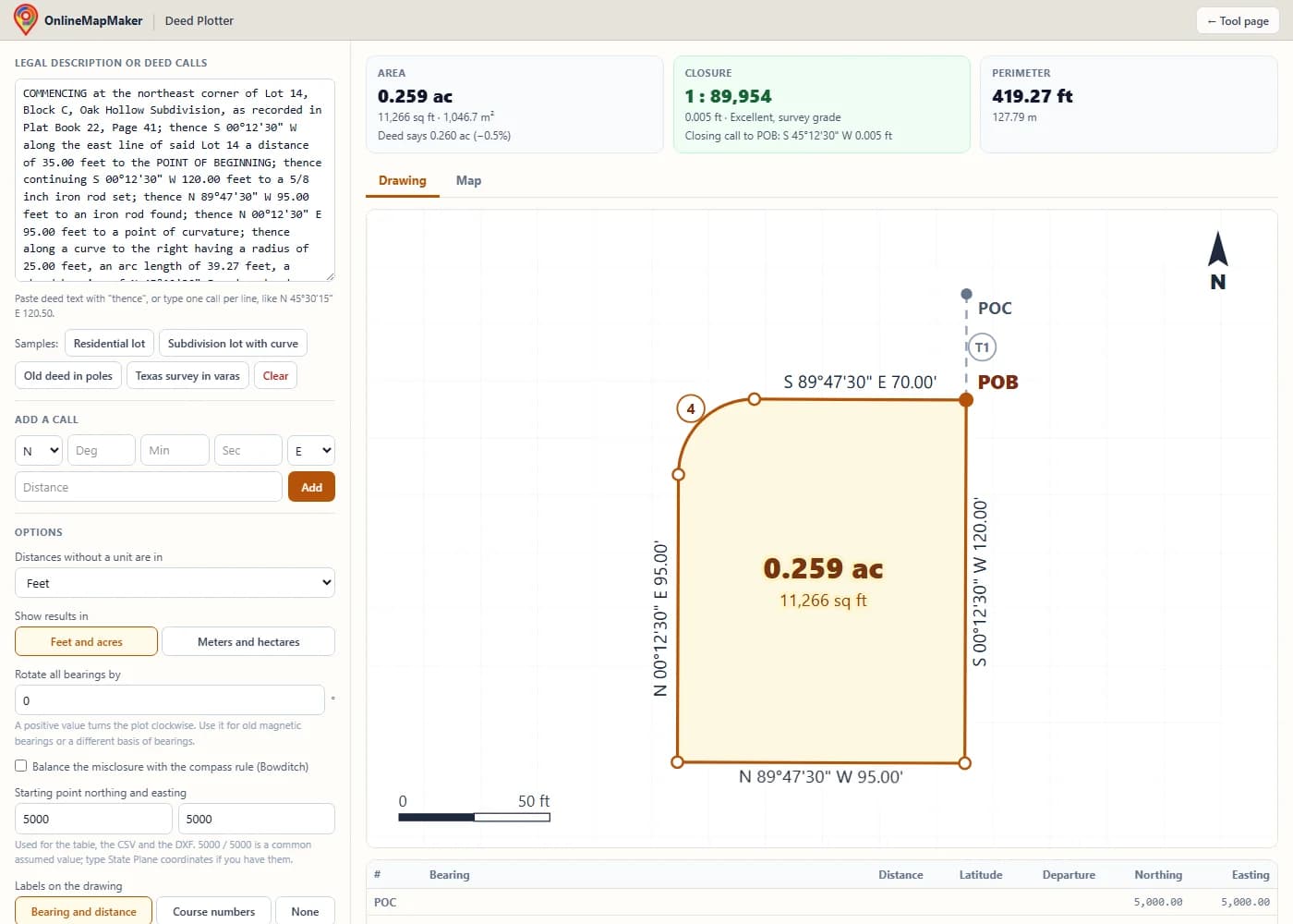
Paste the legal description into the box, or click a sample. Deed text with "thence" and line-by-line calls both work. The plot, the area and the closure update while you type.
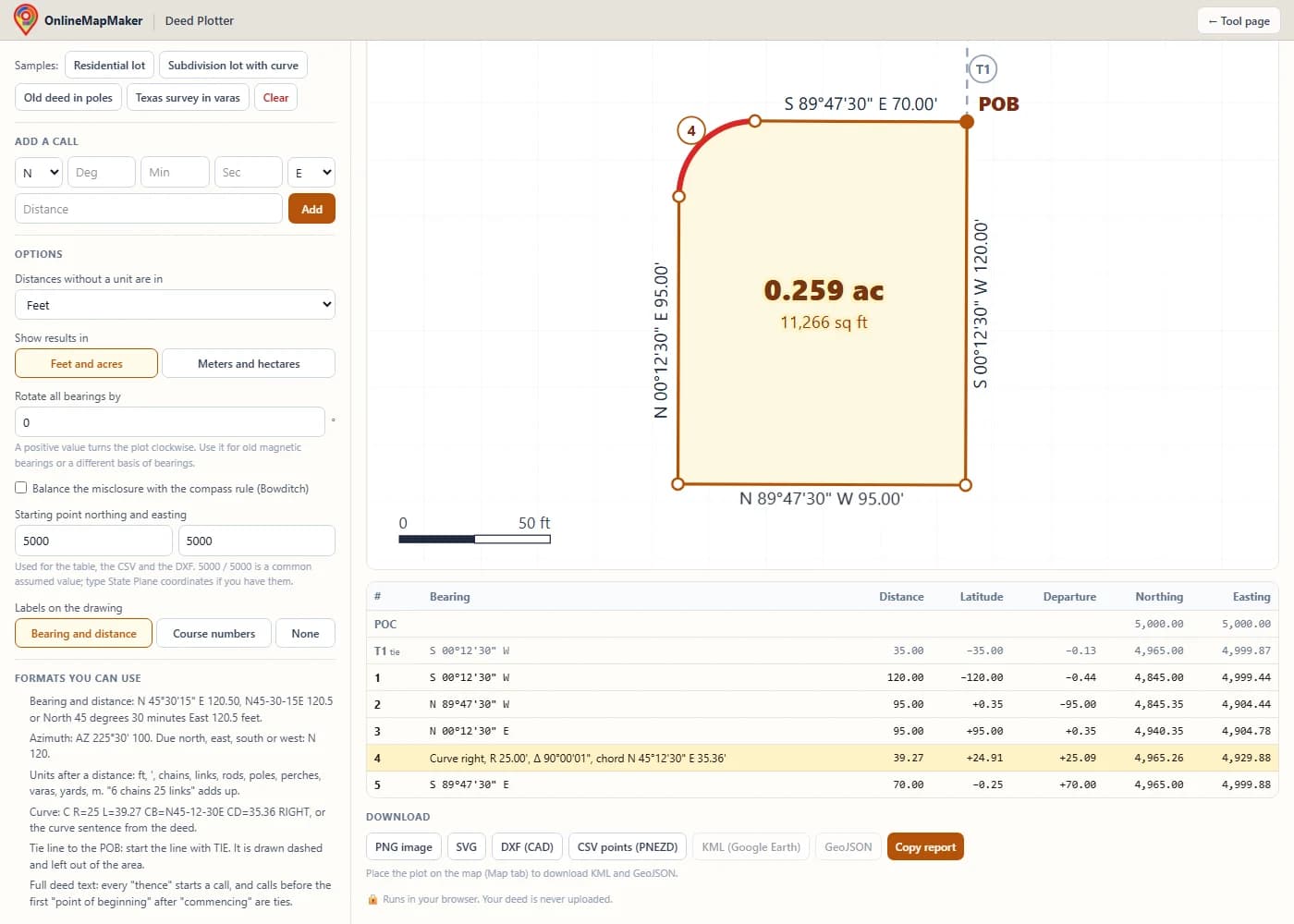
Check the table of courses. Hover a row to see that course in red on the drawing. Any line the plotter could not read is listed above the options, so nothing is skipped without you knowing.
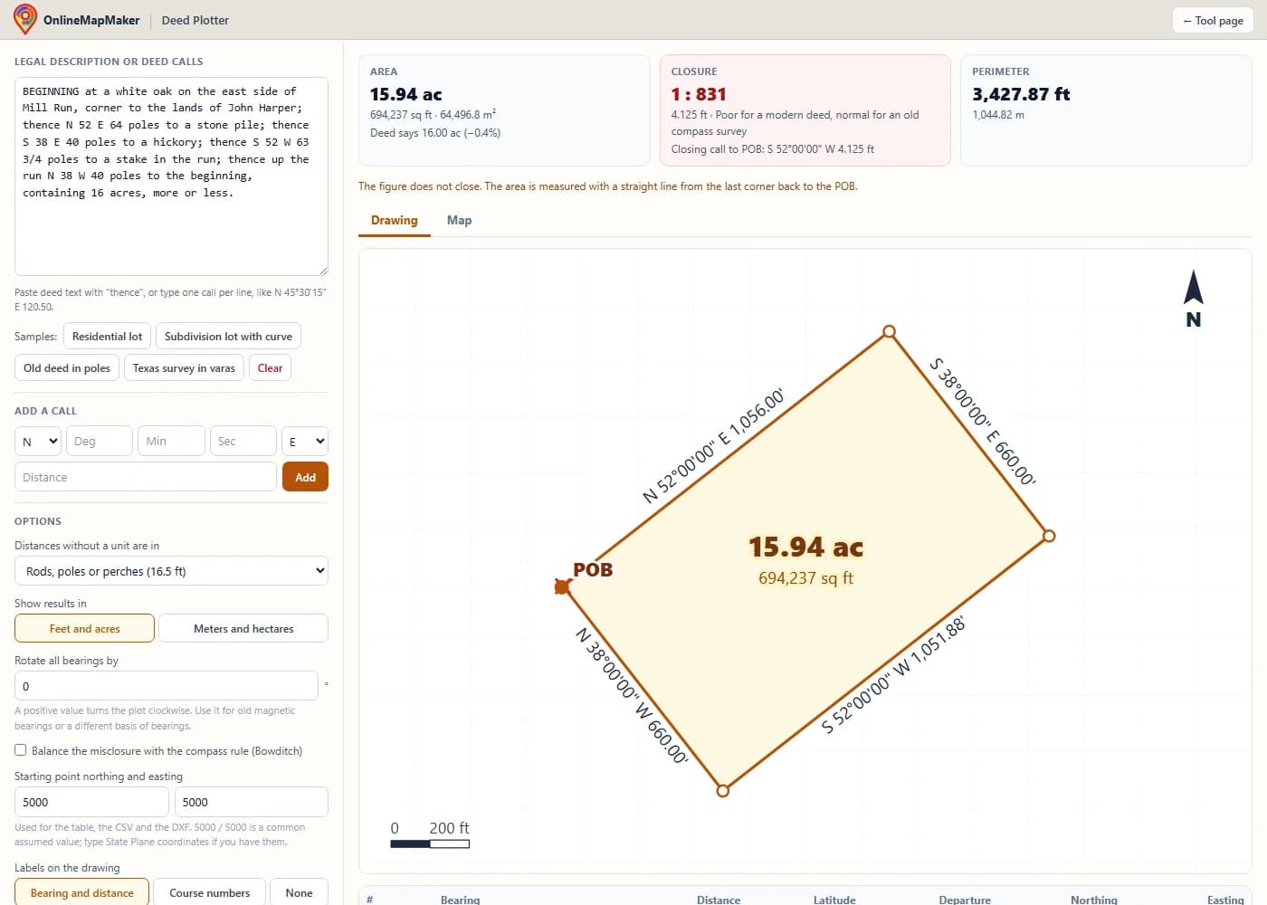
Read the closure. This old deed in poles misses its starting point by about 4 feet, a precision near 1:830, which is normal for a compass-and-chain survey. The red X marks where the last call ends, and the closing call gives the bearing and length of the gap.
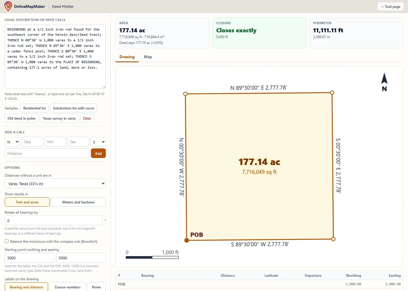
Pick the unit for distances without a unit, switch results between feet and meters, rotate all bearings for an old magnetic basis, or balance the error with the compass rule. Here the Texas sample in varas comes out at one labor, about 177.1 acres.
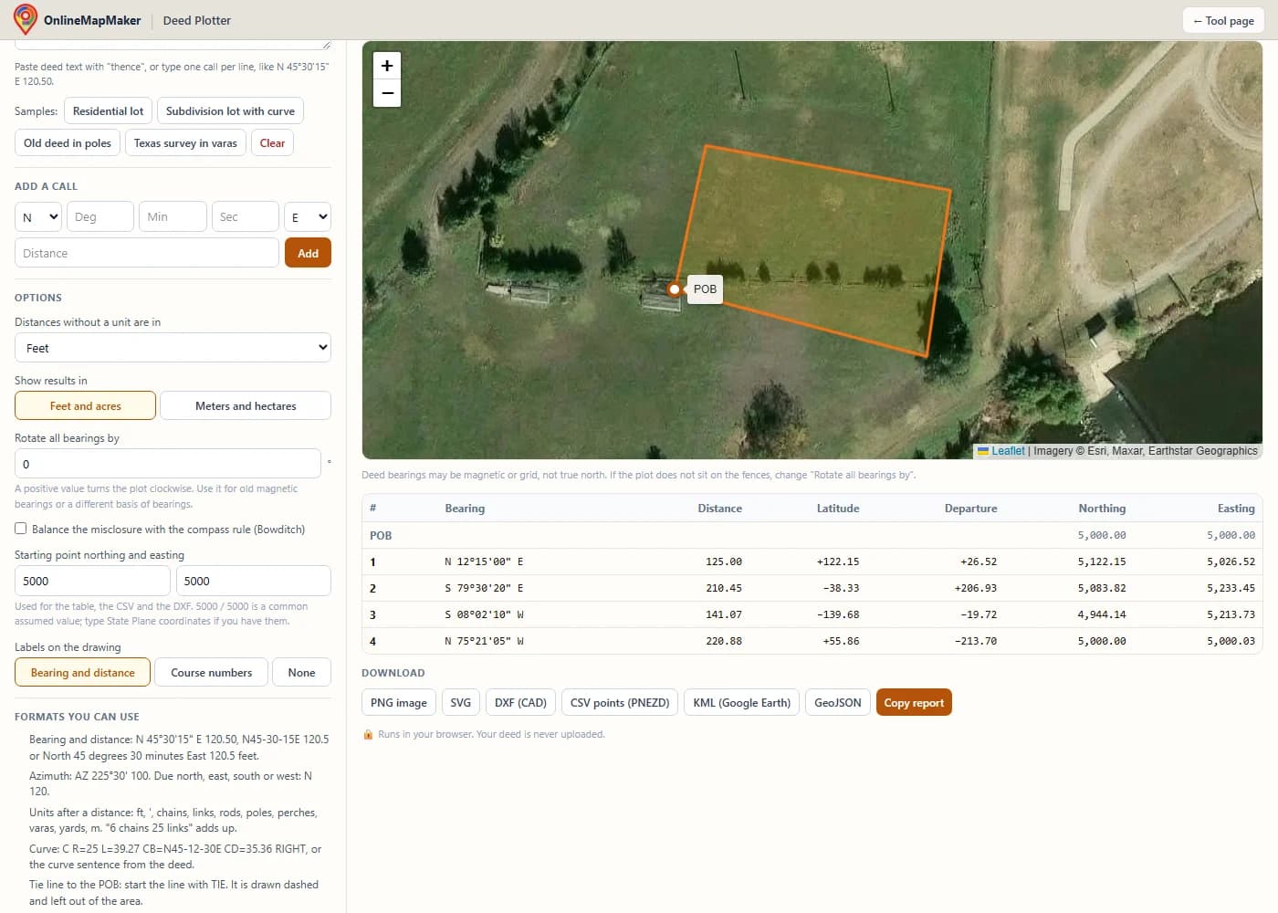
Open the Map tab, click the starting corner on the satellite image (or type its latitude and longitude), and drag it to fine-tune. Then download KML for Google Earth, GeoJSON for GIS, DXF for CAD or a CSV point file.
Who uses a deed plotter
Anyone who has to make sense of a legal description. A few of the people I see using it most:
- Home and land buyers. Before closing, plot the legal description in your title commitment (Schedule A) and compare it to the survey and to what the seller showed you. A shape that looks wrong is a question to ask now, not after closing.
- Landowners checking a fence or a line. Plot your deed and your neighbor's deed, put both on the satellite map from a shared corner, and see whether the fence follows either one.
- Real estate agents. Get a quick acreage and a clean drawing of a rural listing when there is no recent survey, and see road frontage at a glance.
- Title examiners, abstractors and attorneys. Check that a description closes and that the acreage matches before a policy is written. A typo found here saves a corrective deed later.
- Land surveyors. Plot the record descriptions of the subject and the adjoiners before going to the field, check closures in the office, and send the PNEZD file to the data collector.
- Oil, gas, solar and wind landmen. Plot lease and tract descriptions, many in varas or chains, and drop them into Google Earth next to the units and the pads.
- Hunters and timber buyers. See where a tract really runs before you hang a stand or cruise a stand of timber, and take the KML into a mapping app on your phone.
- County GIS and assessor offices. Draw a new split or a parcel from a recorded deed to check the tax map, and export DXF or GeoJSON for the parcel layer.
- Genealogists and local historians. Plot an old land grant or patent written in poles and perches and find the old homeplace on today's map.
- Engineers and site planners. Get a boundary into CAD quickly from a deed for a concept plan, a septic layout or a permit sketch while the full survey is still being done.
Want to measure a shape you draw by hand on an aerial photo instead of one written in a deed? Use the Land Area Calculator. It gives the area of any polygon you click on the map.
Deed plotter FAQ
Is this deed plotter really free?
Yes. There is no account, no trial and no limit on the number of deeds or calls. All the downloads (PNG, SVG, DXF, CSV, KML and GeoJSON) are free too.
Is my deed uploaded anywhere?
No. The parsing, the plot and every calculation run in your browser with JavaScript. The text you paste never leaves your device. The only outside requests are the map tiles, and only after you open the Map tab.
How do I plot my deed in Google Earth?
Plot the deed, open the Map tab and click the spot of the starting corner on the satellite image (or type its latitude and longitude). Drag the white marker to fine-tune it against a fence corner or a road. Then click KML and open the file in Google Earth Pro, or import it in Google Earth on the web under Projects. The parcel and the POB show up as their own layers.
Why does my deed not close?
Usually one of five things: a typo in a bearing or a distance, an N typed for an S or an E for a W, a call left out when the text was copied, a curve read the wrong way (right or left), or the wrong default unit. Look at the closing call: if its length is close to one of your courses, that course is probably missing; if its bearing is close to one of your courses, that distance is probably wrong. Old deeds also simply did not close well, since they were run with a compass and a chain.
What closure is good enough?
For a modern deed or plat, 1:10,000 or better is good and 1:5,000 is the least I would accept without asking questions. For deeds from before about 1900, anything from 1:200 to 1:1,000 is normal. The closure card colors the result green, amber or red to give you a quick read.
The acreage from the plot is different from the deed. Which one is right?
Neither one is "right" until a surveyor measures the land. The deed acreage is the weakest call in a description, which is why it says "more or less". A difference of a few percent is common in older deeds. A large difference in a modern deed usually means a typo, a missing call, or a deed that excepts part of the land out ("less and except") somewhere else in the text.
Can it plot a PLSS description like "the NE 1/4 of the SW 1/4 of Section 12"?
Not by itself. An aliquot description names a part of a section, not a list of bearings and distances, and plotting it needs the actual positions of the section corners. If your deed has a metes and bounds part inside the section, plot that part. The tie call from the section corner can be entered as a TIE line.
Can I enter curves?
Yes. Paste the curve sentence from the deed as it is, or type it short, like C R=25 L=39.27 CB=N45-12-30E CD=35.36 RIGHT. You need the direction (right or left), the radius, and one of the arc length, central angle or chord distance. The chord bearing is optional for a curve tangent to the course before it.
How do I convert chains, rods, poles, perches or varas to feet?
You do not have to: write the unit after the distance or pick it as the default and the plotter converts it. For reference, 1 chain = 66 feet = 100 links, 1 link = 7.92 inches, 1 rod = 1 pole = 1 perch = 16.5 feet, and 1 Texas vara = 33⅓ inches = 2.7778 feet.
My old deed uses magnetic bearings. How do I line it up with the map?
Put "Rotate all bearings by" to the difference between the deed's basis and true north. A positive number turns the plot clockwise. If you do not know the old declination, place the plot on the satellite map at a known corner and change the rotation until one long line sits on its fence or road. Then the other lines should follow.
Can I open the drawing in AutoCAD, Civil 3D, Carlson or QGIS?
Yes. The DXF has the parcel as a closed polyline with true arcs for the curves, the tie lines, corner points and bearing and distance labels on their own layers. The CSV is a PNEZD point file (point, northing, easting, elevation, description) that Civil 3D, Carlson and most data collectors import. Set the starting northing and easting first if you want real State Plane coordinates.
Is a deed plot the same as a survey?
No. A plot only shows what the description says. It does not find the monuments, check the adjoiners, look for gaps or overlaps with the neighbors, or resolve conflicts between calls. For a boundary dispute, a fence, a sale or a loan, hire a licensed professional land surveyor in your state.
What do POB and POC mean?
POB is the point of beginning, the corner where the description of the tract starts and ends. POC is the point of commencement, a known point the deed starts from when the POB itself is hard to find. The calls from the POC to the POB are tie lines.
Does it work on my phone?
Yes. On a phone the input box sits above the drawing. Pasting from a PDF or an email works, and the Map tab can use your phone's GPS to place the starting corner while you stand on it.
The deed plotter draws what a legal description says. It is not a survey, not legal advice, and not a substitute for a licensed land surveyor or a title examination. Check every call against the recorded document. All calculations run in your browser, and nothing you enter is stored on a server. Optional base maps © OpenStreetMap contributors, drawn with Protomaps (hosted by KONAKTIVE), with CARTO as the fallback. Satellite imagery: Esri.